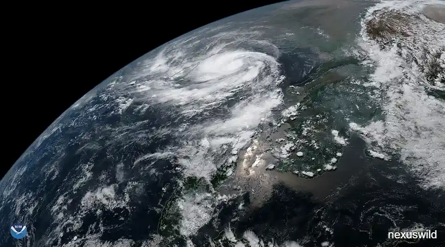

At first light, the sea arrived at Gopalpur
The sea reached Gopalpur before the sun did. By the time the first grey light spread across the coastal belt of Ganjam district on Friday, 20 November 2026, the Bay of Bengal had already begun pushing long, uneven swells over the shoreline, and the wind had turned from a nuisance into something that required people to lean into it. Fishermen had been told days earlier not to put out. Shops along the beach had been covered in polythene. Tourists had been moved away from the water's edge. Schools in the most exposed districts had been shut since Thursday. What remained was the particular hush of a place that has done everything it can and is now waiting.
Cyclonic Storm Akvan made landfall close to Gopalpur that morning, crossing the north Andhra Pradesh–south Odisha coast with sustained winds of roughly 70–80 kmph and gusts to about 90 kmph. By the standards of the Bay of Bengal in late autumn, that is not an exceptional intensity. What made the event consequential was everything that had happened before the wind arrived, and everything that happened in the hours immediately after. Odisha state officials said they had moved more than 3.7 lakh people — over 372,000 — out of low-lying, coastal and landslide-prone settlements and into shelters, community centres and safer buildings across twenty districts. By the end of the day, no deaths had been reported, and no major damage to public infrastructure had been confirmed.
That last point requires care. "No casualties reported" and "no major damage reported" are statements about what officials knew at the time, not final findings. Chief Secretary Anu Garg told reporters that teams were still on the ground, that roads in Berhampur and Digapahandi were inundated and being pumped out, and that the state was monitoring river systems and district control rooms through the night. Revenue and Disaster Management Minister Suresh Pujari said much the same: no major impact from the winds, but rainfall had occurred and assessments were continuing. In disasters of this kind, the first twenty-four hours are a fog of partial information. A zero-death count announced at dusk can change by morning. The damage to homes, crops, roads, power lines and fishing boats is usually measured over days and weeks, not hours. This account reports what was said when it was said.
Akvan was also the third severe cyclonic storm to threaten this stretch of India's eastern seaboard in less than a month, following very severe cyclonic storm Arnab in late October and severe cyclonic storm Murasu in early November. That clustering — unusual, though not unprecedented — is the reason this story is about more than a single landfall. It is about a coastline being tested repeatedly in quick succession, a state administration that has built an elaborate machine for getting people out of the way, and a set of atmospheric and oceanic conditions that experts say made this post-monsoon season unusually productive of storms. Those three threads run through everything that follows.
The IMD timeline: from a forecast landfall in Andhra to a crossing near Gopalpur
The official record of Akvan begins in the third week of November. The system formed over the west-central Bay of Bengal around 17 November 2026 and was named Akvan — a name contributed to the North Indian Ocean naming list by Iran — as it organised. Early projections were considerably more alarming than what eventually occurred. On Wednesday, 18 November, the India Meteorological Department expected the storm to intensify into a very severe cyclonic storm and strike the Andhra Pradesh coast, with landfall somewhere between Machilipatnam and Puri and winds that could reach 90–100 kmph, gusting to 110 kmph.
By Thursday evening the forecast had shifted in two important ways. First, the storm was no longer expected to reach "very severe" intensity; the IMD's 8 p.m. bulletin on 19 November described a severe cyclonic storm moving northwards at about 13 kmph, positioned roughly 350 km south of Gopalpur and 270 km south-southeast of Kalingapatnam in Andhra Pradesh. Second, the projected landfall point had drifted north. The bulletin said the system was likely to move north-northwestward and cross the north Andhra Pradesh and south Odisha coasts close to Gopalpur by noon on 20 November, still with maximum sustained winds of 90–100 kmph gusting to 110 kmph. districts in both states were placed under red and orange rain warnings, and Odisha began the largest evacuation of the season.
The track moved again overnight. In the small hours of Friday, satellite imagery showed what the IMD described as "land interaction" beginning: the storm's cloud mass, already sheared and poorly organised, started brushing the coast well before the centre crossed it. The crossing itself happened earlier than the noon forecast. The Amaravati Meteorological Centre put the landfall window between 7:30 and 8:30 a.m., very close to Gopalpur, near 19.1 degrees north and 84.8 degrees east. The IMD's 8:30 a.m. message placed the centre over south coastal Odisha and adjoining north coastal Andhra Pradesh, moving north-northwestward at 26 kmph, about 120 km northeast of Kalingapatnam, 130 km west-southwest of Puri and 230 km northeast of Visakhapatnam.
The landfall process continued for roughly three hours. The IMD's 11:20 a.m. bulletin declared it complete. By 11:30 a.m. the system had weakened into a deep depression over south coastal Odisha, moving north-northeastward at about 24 kmph. The sequence after that was rapid: a depression within six hours, then a well-marked low-pressure area during the subsequent six hours, with the remnant expected to drift north into Jharkhand. Odisha's Revenue Minister Suresh Pujari gave a slightly later local time for the crossing — between 10:30 and 11 a.m. — a discrepancy that reflects the difference between the meteorological definition of landfall and the administrative observation of it on the ground. Both refer to the same morning.
It is worth noting how much the forecast changed in seventy-two hours: from a very severe storm aimed at Andhra Pradesh, to a severe storm near Gopalpur, to a cyclonic storm at the coast, to a deep depression by late morning. Families in Ganjam and Gajapati were evacuated on the basis of the earlier, harsher prediction. They were not harmed by the weaker reality. That is not luck; it is the intended functioning of a warning system.
Why Akvan weakened before it completed landfall
The downgrade from a severe cyclonic storm to a deep depression within hours of crossing the coast was not a surprise to the IMD. Director-General of Meteorology Mrutyunjay Mohapatra told reporters on Friday that the three factors the agency had flagged in its bulletins had all materialised as expected. They were land interaction, the intrusion of cold, dry air from northwest India, and a sharp increase in vertical wind shear.
Each deserves a moment of explanation. Land interaction is straightforward: once the circulation of a cyclone begins to move over a rough, non-uniform land surface, it loses the smooth supply of heat and moisture from the ocean that fuels it, and friction begins to tear at the low-level winds. Cold, dry air entering the storm's circulation has a similar effect, destabilising the warm, moist core that keeps the system organised. Vertical wind shear — the difference in wind speed and direction between the lower and upper levels of the atmosphere — is perhaps the most destructive of the three. High shear tilts the storm's axis, displacing the upper-level outflow from the low-level inflow and effectively decapitating the heat engine.
Mohapatra's description was precise: "As we gave an indication in our bulletin, while approaching the coast, the cyclone would experience interaction with the land surface, and there would also be an intrusion of cold and dry air from northwest India. The third factor was vertical wind shear, the difference in wind speed between the lower and upper levels of the atmosphere, which was expected to increase. All three factors occurred as expected and led to the weakening of the system from a severe cyclone to a cyclonic storm."
Officials in Odisha and Andhra pointed to two additional factors. Hindustan Times reported that the system had a broad and poorly organised circulation and had moved rapidly over the sea, giving it less time to consolidate before landfall. The Visakhapatnam Meteorological Department said the storm had begun weakening the previous night. An IMD bulletin noted that the cloud mass associated with Akvan was "sheared" as it reached the coast — a visible signature of what the forecasters had been expecting.
The practical consequence was a large gap between the forecast intensity and the realised one. Where the 19 November bulletin had warned of 90–100 kmph winds gusting to 110, the actual crossing carried 70–80 kmph gusting to 90. At 8:30 a.m. the IMD put current wind speeds at about 60–70 kmph gusting to 80 along and off the southern Odisha coast. Hindustan Times reported that the storm had been forecast to make landfall as a severe cyclonic storm with 90–100 kmph winds but "weakened considerably" on Friday morning.
That gap is not a forecasting failure in the way the public sometimes assumes. Tropical cyclone intensity forecasting remains one of the harder problems in operational meteorology, particularly in the Bay of Bengal, where storms are often small, rapidly evolving and influenced by nearby landmasses. What matters for public safety is that the warning was issued early enough and conservative enough that the evacuation proceeded on the basis of the worse scenario. The state did not wait to see whether the storm would weaken before moving people. By the time it did weaken, more than three lakh people were already out of harm's way.
The evacuation: three lakh, then four
If Akvan's landfall was meteorologically unremarkable, the evacuation that preceded it was anything but. The numbers climbed steadily through Thursday and Friday as the storm's track shifted north and the state's relief machinery widened its net.
On the evening of 19 November, Special Relief Commissioner Rajesh Pravakar Patil said roughly 2.98 lakh people had been relocated from more than 2,000 locations. Ganjam district alone accounted for about 1.38 lakh. The landslide-prone districts of Gajapati and Kandhamal had moved 22,000 and 13,000 people respectively. About 4,200 pregnant women had been placed in secure locations. The New Indian Express, reporting early on 20 November, put the state figure at more than three lakh across twenty districts, with 4,170 pregnant women shifted and 1,317 already delivered. By Friday evening, ANI quoted the Revenue Minister as saying around 3,72,000 people had been evacuated across districts, including 4,467 pregnant women moved to primary and community health centres, of whom 1,452 had delivered, with mothers and babies safe. The Indian Express reported 4,470 pregnant women shifted and more than 1,400 deliveries. Chief Secretary Anu Garg told ETV Bharat that nearly 3.72 lakh people had been moved to nearly 10,000 designated shelters, with 4,470 pregnant women relocated and 1,450 deliveries.
These figures are not contradictory so much as sequential. They were recorded at different hours by different officials using different reporting chains, and they describe a moving operation. A count taken at 10 p.m. Thursday is not the same as one taken at 10 p.m. Friday. The consistently reported figure at the end of the cycle is approximately 3.72 lakh, and that is the number used in the headlines. The variation in the maternal-health figures — 4,170, 4,467, 4,470 — is similarly a matter of timing and definition: women shifted to shelters versus women shifted specifically to health centres, and deliveries recorded by midnight versus earlier in the day.
The geography of the evacuation tells its own story. Ganjam, the district where the storm crossed, was always the focus. But the state also evacuated hilltop and foothill hamlets in six districts identified as landslide-prone: Ganjam, Gajapati, Rayagada, Kandhamal, Malkangiri and Koraput. The Odisha Space Applications Centre had identified 941 such locations, including 211 in Gajapati, 169 each in Ganjam and Rayagada, 163 in Kandhamal, 151 in Koraput and 78 in Malkangiri. Ghat roads such as Kalinga and Gajalbadi, which connect Ganjam and Kandhamal, were barricaded in anticipation of landslides. It was a measure of how seriously the state took the rain threat even after the wind threat receded.
Shelter capacity was prepared at scale. The Hindu reported on 19 November that as many as 9,341 cyclone shelters had been readied across the state, with 2,623 made operational. The New Indian Express reported the same total. ETV Bharat said people were moved to nearly 10,000 designated shelters by Friday. Again, the numbers reflect readiness versus actual use. Community kitchens — more than 665 of them, according to Commerce and Transport Minister Bibhuti Bhusan Jena — were set up to feed those who had been moved. The state's priority, Jena said, was "zero casualties".
The human detail is easy to lose in the totals. An ETV Bharat report filed before landfall described a doctor and an ambulance crew in Kendrapara carrying a pregnant woman five kilometres to safety. Such episodes are the granular reality behind a number like 4,467. Officials said that of the women shifted to health centres, more than 1,400 gave birth in the days around the cyclone, and that both mothers and newborns were safe. The Indian Express reported that the chief secretary described the river systems — particularly the Rushikulya and Bahuda basins — as being closely monitored, with no adverse situation or disruption reported as of Friday.
Inside the 'zero casualty' mission
"Zero casualty" is not a slogan in Odisha; it is an operational doctrine that the state has refined over two decades of cyclones. Akvan was the third test of that doctrine in twenty-four days, and the machinery was visible at every level of the response.
Chief Minister Mohan Charan Majhi chaired a high-level review at the Special Relief Commissioner's office in Bhubaneswar on Thursday night and again on Friday, after the landfall. The Hindu reported that senior bureaucrats were assigned to individual districts, with sixteen IAS officers deployed to monitor rescue and restoration work. Ganjam and Gajapati, the two districts closest to the crossing, received seventeen satellite phones for key personnel so that communication could be maintained if mobile networks failed. The state's Disaster Management Unit had instructed telecom providers to activate intra-circle roaming in Ganjam, Gajapati, Puri, Kendrapara, Jagatsinghpur and Khordha on 20 November. Seventy cell-on-wheels units, 197 mobile diesel generator sets and 61 support teams were positioned to keep communications alive.
The deployment of response forces was similarly specific. The New Indian Express listed 418 field-level teams: 60 units of the Odisha Disaster Rapid Action Force, 14 of the National Disaster Response Force, 216 from the Odisha Fire Service and 128 tree-cutting teams from the Odisha Forest Development Corporation, with another 28 fire service teams on standby. The Hindu's live coverage on Friday gave a slightly different total — 423 rescue teams — a difference that likely reflects the inclusion of additional district-level or central forces as the day progressed. Hindustan Times reported 418 teams from ODRAF, NDRF and Fire Services with 28 more on standby.
Water management was handled before the storm rather than after it. Chief Secretary Anu Garg said the Water Resources Department had begun depleting reservoirs in affected districts, with two gates of a major dam and 23 gates of medium irrigation dams kept open. Commerce and Transport Minister Bibhuti Bhusan Jena said water levels in all dams had been reduced by more than 50 per cent in advance. Food, drinking water and anti-snake venom medicines were pre-positioned, and the state remained in constant contact with oil companies to avoid fuel shortages during rescue and relief. These are the unglamorous preparations that determine whether a evacuation succeeds.
At the centre of it all was the state Emergency Operation Centre in Bhubaneswar, where officials monitored district collectors and control rooms through the night. Garg said the administration stayed in contact with senior officials continuously. On Friday, as the storm weakened and waterlogging appeared in urban areas, the focus shifted from evacuation to dewatering: the state's Information and Public Relations Department reported that pumping was underway at 34 locations and tree-cutting at two as of 9 a.m.
Two caveats belong here. First, the "zero casualty" framing is a statement of intent and an early result, not an audit. No deaths had been reported by the time these officials spoke. Second, the success of the evacuation cannot be attributed solely to the final track. Had Akvan maintained its earlier intensity and struck farther south with 110 kmph gusts, the same shelters and the same teams would have faced a far harder test. What can be said is that the state acted on the stronger forecast and did not wait for certainty.
Rain, waterlogging and a coastline under stress
The wind did relatively little. The rain did a great deal.
Ganjam district recorded the highest rainfall totals in the 24 hours around landfall. The Hindu BusinessLine, citing IMD figures, reported Patrapur at 209 mm, Hinjili at 207 mm, Chikiti at 199 mm, Gopalpur at 190 mm and Chhatrapur at 139 mm — all in Ganjam. ETV Bharat reported a district average of 114.06 mm for Ganjam in the twenty-four hours to 8:30 a.m. Friday, with Kendrapara at 64.6 mm, Puri at 61.1 mm, Kandhamal at 33.5 mm and Gajapati at 21.9 mm. The IMD station at Gopalpur recorded 180.4 mm, Chandbali 96.6 mm and Paradip 85.6 mm. The Indian Express said several places in Ganjam received close to 200 mm in the preceding day.
Hindustan Times reported heavy rainfall across Bhadrak, Cuttack, Gajapati, Ganjam, Jagatsinghpur, Jajpur, Kendrapara, Khurda, Nayagarh and Puri, with more rain expected over the following two days. The Hindu reported that Paradip recorded 84 mm and Puri 73 mm, and that a yellow warning remained in place for Paradip. The Regional Meteorological Centre in Bhubaneswar forecast heavy rain across Odisha for two days, with coastal and southern districts worst affected.
On the ground, the consequences were urban and immediate. Garg said roads in Berhampur and Digapahandi were inundated and that teams with high-capacity pumps had been deployed to clear them. Visuals from Berhampur showed water standing in Gajapati Nagar, Nilachal Nagar and Jayaprakash Nagar. In Visakhapatnam, high tidal waves caused severe coastal erosion along a stretch of shoreline near the INS Kursura Submarine Museum, according to The Hindu. At Puri, rough seas and strong winds persisted at the beach through Friday, with NDRF and other relief teams maintaining a heavy presence.
North of the border, the rain was intense in places that had already been saturated by earlier storms. The Hindu reported that sixteen weather stations in Srikakulam district recorded more than 100 mm between Thursday night and 7 a.m. Friday, with Ichchapuram mandal topping the list at 153.25 mm, followed by Ms Pally in Kanchili mandal at 128.25 mm, the anganwadi area in Palasa at 126.5 mm and Rajapuram in Kaviti mandal at 123.75 mm. The Amaravati Meteorological Centre said more than half the stations in north coastal Andhra Pradesh — Srikakulam, Vizianagaram and Anakapalli — recorded light to moderate rain with patches of heavy showers, and that many places in Ichapuram, Sompeta and Mandasa received more than 12 cm.
The state's red and orange warnings were extensive. ETV Bharat reported a red alert for Balasore and Mayurbhanj, forecasting extremely heavy to exceptionally heavy rainfall at isolated places, with an orange alert for Bhadrak, Kendrapara, Jagatsinghpur, Jajpur, Dhenkanal, Cuttack, Khurda, Puri, Ganjam and Gajapati. ANI quoted Minister Pujari as saying that after the system crossed the coast, Mayurbhanj and Balasore were in the red zone, thirteen districts including Keonjhar, Bhadrak, Jajpur, Cuttack, Khordha, Puri, Kandhamal, Gajapati and Ganjam were in the orange zone, and the remaining districts were in yellow.
Rainfall figures of this kind are preliminary by nature. They come from automatic weather stations, manual gauges and district reports, and they are revised as data is quality-checked. The totals cited here reflect what was being reported on 20 November. They should not be read as a final hydrological record of the event.
Trains, schools and a state that paused
The disruption to ordinary life was immediate and wide. The most visible element was the rail network, which had been shut down as a precaution before the storm arrived and was reopened gradually as conditions improved.
The Hindu reported that the East Coast Railway cancelled 41 trains scheduled for 19, 20 and 21 November, while the South Eastern Railway cancelled at least 28 express trains on Friday, many of them heading to or passing through Puri. The tally reported on Friday morning was 69 trains cancelled across the two zones. By later in the day, figures circulating in the media included 47 trains cancelled and 28 rescheduled — a difference that reflects separate announcements by different railway zones and the fact that cancellations and rescheduling were being amended as the storm weakened. Chief Minister Majhi's office cited 47 cancelled and 28 rescheduled. Hindustan Times reported 47 cancelled, including 41 by the East Coast Railway, and 28 rescheduled.
Railway Minister Ashwini Vaishnaw visited the war room at Rail Bhavan in New Delhi on Friday and reviewed arrangements for passenger safety and smooth operations, according to a Railway Ministry press note reported by PTI and carried by The Hindu. Officials said precautionary cancellations were being lifted progressively, keeping prevailing conditions and passenger safety in mind. Bus services in Ganjam district remained suspended through Friday.
Schools were closed across the affected belt. DW reported that schools in Ganjam, Gajapati, Puri, Jagatsinghpur, Kendrapara and Kandhamal were shut for three days from Thursday, with Malkangiri, Rayagada and Koraput added for Thursday and Friday. In Jharkhand, where the remnant system was expected to move, primary classes were suspended in East Singhbhum and Seraikela-Kharsawan districts as a precaution.
The Odisha Assembly did not sit. Speaker Surama Padhy adjourned proceedings until the morning of 23 November after an all-party meeting, asking legislators to use the recess to assist people in their constituencies. It is a small but telling detail: the state's elected representatives were redeployed as relief workers.
Tourism and fishing were also brought to a halt. Beaches and major tourist sites in Odisha were shut ahead of landfall, and the Gopalpur Port was instructed to secure its machinery and ships. Fishermen along both the Odisha and Andhra coasts were advised not to venture into the sea. The Hindu reported that fishermen from Andhra Pradesh stranded near the Odisha coast were being brought safely to Ganjam with help from the Indian Coast Guard. At Puri, the beach remained under surveillance by NDRF and other teams on Friday morning.
It should be stressed that these measures were precautionary. Some were lifted within a day. The social and economic cost of cancelled trains, closed schools, suspended buses and halted fishing is real but has not been quantified, and no reliable estimate was available at the time of writing.
The storm did not stop at Odisha
Akvan's influence extended well beyond the district where it crossed. As the system moved north and northeast, it dragged bands of rain into neighbouring states and revived concerns in areas that had already been soaked by two previous cyclones.
In Andhra Pradesh, Srikakulam and Vizianagaram were placed under red alert, with several other districts under orange and yellow warnings. The heavy rain in Ichapuram, Sompeta and Mandasa — more than 12 cm in places — was recorded before the centre had fully crossed the coast. The threat to Visakhapatnam, which had been in the earlier forecast cone, largely dissipated; The Hindu reported on Friday morning that winds along the Visakhapatnam coast were blowing at only 20–30 kmph, with rough sea conditions. Clouds gathered over the city and a blanket of mist settled over the hills, but the anticipated direct hit did not materialise.
In Jharkhand, the IMD issued an orange alert for heavy rain in five districts — Dhanbad, Bokaro, Seraikela-Kharsawan, East Singhbhum and West Singhbhum — until 8:30 a.m. Saturday, with a yellow alert for seven others including Ranchi, Gumla and Simdega. Abhishek Anand, deputy director of the Ranchi Meteorological Centre, said rainfall was likely to intensify later in the day, with some districts possibly receiving very heavy rain, thunderstorms, lightning and gusty winds up to 50 kmph. Light rain was reported in parts of the state on Friday morning.
West Bengal saw sustained rainfall across its southern districts. The Hindu reported that Kolkata, North 24 Parganas, Howrah, Hooghly and Purulia were under warnings for heavy rain with thunderstorms and gusty winds, while South 24 Parganas, Purba Medinipur, Paschim Medinipur, Jhargram and Bankura were likely to receive heavy to very heavy rainfall. India Today reported light to moderate rain in Kolkata on Friday, disrupting public transport during the morning commute. Squally winds of 40–50 kmph gusting to 60 kmph were expected along the West Bengal coast until Friday noon. The state's Urban Development and Municipal Affairs Minister, Agnimitra Paul, said workers and officers were on alert and that the state was coordinating with power, port, disaster management and public works departments.
Unseasonal rain also fell in parts of Chhattisgarh, including the capital, Raipur, according to India Today. The reach of a weakening tropical system can be surprisingly broad: even after the wind field collapses, the remnant moisture plume can interact with other weather systems hundreds of kilometres inland.
Analysts were watching the remnant's path into Jharkhand with some concern. The state had already received significant rain from earlier systems, and the IMD's guidance pointed to continued heavy falls through Friday and into Saturday before conditions improved on 22–23 November. For communities in low-lying or mining-affected areas, a second round of rain from a decaying cyclone can be more troublesome than the landfall itself.
A third cyclone in twenty-four days
Akvan's place in the record books is less about its intensity than its timing. It was the third cyclonic storm to threaten India's east coast within roughly three weeks, and the third to affect Andhra Pradesh or Odisha in rapid succession.
The sequence began on 28 October, when very severe cyclonic storm Arnab made landfall near Narsapur in West Godavari district. On 3 November, severe cyclonic storm Murasu struck close to Ongole in Prakasam district. Akvan followed on 20 November, crossing near Gopalpur in Odisha after initially being forecast for Andhra. The Hindu BusinessLine described it as "the third of its kind to threaten the state in 24 days" — a reference to the short interval between Murasu and Akvan. BusinessLine and The Hindu also reported that Andhra Pradesh had been hit by two back-to-back storms since 28 October before Akvan arrived.
Three tropical storms striking the same coast in a single post-monsoon season is unusual. The Hindu's explainer, published on 18 November, noted that comparable clusters had occurred in 1976, 1987 and 2013. Both 1976 and 1987 were El Niño years, and the article observed that 2026 had also been categorised as a super El Niño year. The comparison is suggestive rather than conclusive. A handful of years is a small sample, and the presence of El Niño in two of the three analogues does not by itself establish causation for the third event. The article cited experts, not an official IMD attribution study, and no formal attribution of Akvan to any specific climate driver had been published at the time.
There is also a naming detail worth recording. Akvan is a name contributed by Iran under the system by which North Indian Ocean cyclones are named jointly by member countries of the World Meteorological Organization's regional body. The name was assigned when the system organised over the Bay of Bengal. Cyclone names in this basin are retired when a storm is particularly destructive; whether Akvan's name is retained will depend on the final damage assessment, which was still underway.
The recurrence matters for a practical reason. When storms arrive in quick succession, the ground is already saturated, rivers are already high, reservoirs may still be drawn down, and relief supplies and personnel may not have been fully replenished from the previous event. Officials in Odisha referred explicitly to the earlier storms when describing their preparations. Jena told ANI that after the "intense impact" of Arnab, the state faced Akvan and prepared comprehensively. Andhra Pradesh Chief Minister Chandrababu Naidu sought Rs 96.33 crore in aid for crop damage from Arnav and Murasu on the same day Akvan made landfall, according to ANI — a reminder that the cost of the earlier storms was still being counted when the next one arrived.
What experts say was driving the Bay of Bengal into overdrive
The physical explanation for an active post-monsoon cyclone season over the Bay of Bengal involves several ingredients acting together, and experts quoted in The Hindu's 18 November explainer were careful not to reduce it to a single cause.
The first is sea surface temperature. S.S.V.S. Ramakrishna, a former head of the Department of Oceanography and Meteorology at Andhra University who has spent more than four decades studying Bay of Bengal cyclones, said that in October and November the bay consistently retained sea surface temperatures above 26.5 degrees Celsius. Anything above about 26 degrees is considered conducive to cyclone formation. Warm water supplies the latent heat that powers these systems, and a bay that stays warm through successive storms can keep regenerating new ones.
The second ingredient is what Ramakrishna described as a "barrier layer". The Ganga, Brahmaputra and Godavari rivers discharge enormous quantities of fresh water into the bay during and after the monsoon. Because fresh water is less dense than salt water, it forms a low-salinity layer at the surface. That layer inhibits the mixing of cooler, deeper water upward. Normally, a passing cyclone stirs the ocean and cools the surface behind it, making it harder for the next storm to form. The barrier layer disrupts that brake. As Ramakrishna put it, a passing cyclone like Arnab or Murasu does not cool the sea surface enough to stop the next storm from forming days later.
The third factor is El Niño — but with a counterintuitive twist. El Niño typically suppresses the southwest summer monsoon over India. Its effect on the northeast winter monsoon and on post-monsoon cyclogenesis in the Bay of Bengal is the opposite: it tends to make both more active. During El Niño years, the northeast monsoon is significantly more active over southern peninsular India, creating continuous moisture convergence and frequent convective disturbances over the southern bay — what Ramakrishna called "a steady assembly line of low-pressure areas". The bay is also almost landlocked compared with other tropical ocean basins, which gives its cyclones a slightly different character from storms elsewhere.
The fourth factor is steering. Persistent upper-tropospheric ridges — anticyclonic circulations over the China–Myanmar region and central India — acted as barriers that prevented storms from recurving northeastward into the open ocean and instead pushed them northwestward toward the Andhra and Odisha coasts. Reduced vertical wind shear over the southern bay, linked to El Niño-modified upper-level wind patterns, gave developing systems more room to organise.
Ramakrishna also noted a rarer pathway: on occasion, remnants of a Pacific cyclone cross the Strait of Malacca, re-enter the Bay of Bengal and intensify. He cited the 1999 Odisha super cyclone as an instance of this phenomenon. There was no indication that Akvan had such an origin.
These explanations come from expert interviews and should be read as informed interpretation rather than settled science. No peer-reviewed attribution study of the 2026 post-monsoon season had appeared by 20 November, and the relative weight of each factor for any individual storm remains a matter of professional judgement. What is not in doubt is the operational consequence: a bay that stayed warm, a monsoon that stayed active, and a set of steering patterns that repeatedly aimed storms at the same stretch of coast.
Recovery, the next 48 hours and what remains unknown
By the evening of 20 November, Akvan no longer existed as a cyclonic storm. The IMD said the remnant had weakened into a depression over south Odisha and was likely to move northwards and degenerate into a well-marked low-pressure area within six hours. IMD Director-General Mrutyunjay Mohapatra said record rainfall had been recorded in northern Odisha and Andhra Pradesh over the preceding twenty-four hours. Rain was expected to ease on Friday, but heavy to very heavy falls remained possible in central and northern Odisha, particularly as the system moved inland.
The state's immediate tasks were prosaic and urgent. Pumps were working in Berhampur and Digapahandi. Tree-clearing teams were removing obstructions from roads. Dam levels, already reduced before landfall, were being monitored. Engineers were watching the Rushikulya and Bahuda river basins, where heavy rain had fallen but no adverse situation had been reported as of Friday. The chief secretary said officials were in touch with district collectors throughout the night. Relief materials, food and water had been pre-positioned. Community kitchens were operating.
The larger assessment had barely begun. Officials had reported no deaths and no major damage to public infrastructure, but that statement came with an implicit expiry date. In the aftermath of a cyclone that deposited 200 mm of rain in places, the true extent of damage to kutcha houses, agricultural crops, fishing boats, power distribution lines, roads and embankments takes days to establish. Insurers and government teams had not yet produced loss estimates. The economic cost to Odisha and Andhra Pradesh — including cancelled rail services, suspended fishing, school closures and disruption to tourism — was unquantified.
There is also the question of cumulative impact. Arnab, Murasu and Akvan arrived within a single planting and harvest window. Farmers in coastal districts were already seeking compensation for crop damage from the earlier storms when Akvan's rain fell. Repeated saturation raises the risk of landslides in the hilly districts of Gajapati, Kandhamal and Rayagada, where nearly a thousand vulnerable locations had been identified and residents moved out as a precaution. Those evacuees could not be sent home simply because the wind had stopped.
What happens next depends on two things: how quickly the remnant system dissipates, and how well the state's relief machinery holds up through a second round of rain. The IMD expected conditions to improve over Odisha by 22–23 November. If that holds, the focus will shift from rescue to restoration — reopening roads, restoring power, draining standing water, assessing houses and deciding when schools and ferry services can safely resume.
The broader lesson is likely to be studied well beyond this week. Odisha evacuated more than 3.7 lakh people on the basis of a forecast that ultimately overstated the storm's intensity. The storm weakened, the winds were gentler than promised, and no deaths were reported. But the correct reading of that outcome is not that the forecast was wrong and the evacuation unnecessary. It is that a warning system worked exactly as it should: it identified a credible threat early, the state acted on the worst plausible version of that threat, and the population was moved before the uncertainty resolved. In a part of the world where the bay can spawn three storms in a month, that discipline matters more than any single landfall.
Nexuswild welcomes factual corrections. Email contact@nexuswild.com with evidence and the article URL.