
ISRO Prepares for October 30 NVS-03 Satellite Launch
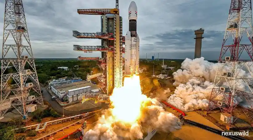
The Indian Space Research Organisation (ISRO) is getting ready to launch its NVS-03 navigation satellite on October 30 2026. This launch could make India’s own satellite navigation system stronger. The NVS-03 will travel inside the Geosynchronous Satellite Launch Vehicle (GSLV) from the Satish Dhawan Space Centre in Sriharikota Andhra Pradesh.
This mission is important because NVS-03 is part of the generation of satellites made for India’s Navigation with Indian Constellation, which many people call NavIC. NavIC was created to give people positioning, navigation and timing across India and about 1,500 kilometres outside of India.
India uses satellite navigation for things from transport and sea travel to emergency help and military work. NavIC is meant to be another source that India controls itself so India does not have to rely on navigation systems run by other countries.
The launch happens at an important time for the programme. Issues with the navigation satellites have made NavIC less able to give independent positioning services. If the NVS-03 launch is successful and the satellite is then put into service and added to the constellation this could fix that problem.
Still October 30 is the planned launch date. The success of the mission will depend on how the launch vehicle works, whether the NVS-03 reaches its planned orbit and whether all later checks finish successfully.
Source: The Indian Express, October 22 2026
What Is NVS-03 and Why Is It Important?
NVS-03 is the third satellite in ISRO’s second-generation NavIC series. The NVS programme is meant to replace and strengthen India’s satellite navigation constellation as older spacecraft get close to or go beyond their planned lifetimes.
United News of India says the NVS-03 weighs 2,250 kilograms and will be launched with GSLV from the spaceport’s Second Launch Pad.
Unlike Earth‑observation satellites that take pictures of the planet a navigation satellite sends signals that receivers use to find location, speed and time. These signals work together with satellites, ground‑control stations and user devices.
Navigation satellites have to stay in planned orbits and keep their timing correct. Their signals go far so even a tiny timing mistake can change a position. Because of this satellite clocks orbit checks and ground control are important parts of the system.
NVS-03 is part of an update plan that keeps NavIC useful for both civilian and strategic work. The second-generation programme adds features like extra navigation signals that make the system work better and give more options.
The importance of NVS-03 should be seen in the constellation. One satellite can help the system. Reliable navigation needs enough working spacecraft correct timing and a good supporting network.
Source: United News of India, October 24 2026
What Is NavIC Indias Indigenous Alternative to GPS?
NavIC means Navigation with Indian Constellation. It was first called the Indian Regional Navigation Satellite System or IRNSS. The programme was made so India could have its regional system for positioning, navigation and timing that uses satellites.
NavIC covers India and a region 1,500 kilometres outside India. So NavIC is regional not global.
This difference matters because many other satellite navigation systems work worldwide. The United States runs the Global Positioning System (GPS) Russia runs GLONASS the European Union runs Galileo and China runs BeiDou.
India does not want to replace those systems in devices. Instead NavIC gives another navigation option that India controls helping tasks that need regional coverage and an independent system.
NavIC has two services. The Standard Positioning Service is for civilians and general users. The Restricted Service gives a protected service for approved users, such, as defence work.
Receivers that work with NavIC can use its signals to find their position. Depending on the receiver and the signals it can get NavIC can help track vehicles, map places, guide ships, set clocks and other services that need location.
A stronger NavIC constellation also makes India more resilient. If a foreign navigation service stops working in a situation or cannot meet a need a good domestic system gives another source of position and timing.
Nonetheless the availability of NavIC does not mean that every smartphone automatically uses NavIC.
Device support depends on hardware, software and compatible signals. Many smartphones already combine signals from satellite navigation systems.
Source: The Indian Express, October 24 2026
Why Indias Navigation System Needs NVS-03
The immediate significance of NVS-03 lies in the operational limitations affecting India’s existing navigation constellation.
In a report published on October 24 India Today explained that NavIC’s independent positioning capability had been affected by a shortage of satellites. The report said that three satellites were providing positioning, navigation and timing services through the system.
Satellite navigation receivers generally need signals from at four satellites to calculate a three‑dimensional position and correct the receiver’s clock error. With three operational NavIC satellites available for positioning NavIC cannot currently provide standalone positioning in the usual way.
This does not mean that all navigation services in India have stopped working. Smartphones, vehicles and other equipment can continue using GPS and other supported satellite navigation systems. NavIC’s timing and other available services may also continue to operate when NavIC’s standalone positioning capability is limited.
The difference is between access to navigation through any satellite system and the ability to determine a position independently using India’s own constellation.
That distinction is particularly important for applications. A domestic navigation network can provide a layer of resilience for systems that need reliable location and timing information.
NVS-03 is expected to help restore NavIC’s standalone positioning capability once NVS-03 has reached its orbit completed commissioning and become operational. The extent of the improvement will depend on NVS-03’s performance and the condition of the constellation.
The mission therefore represents a step towards strengthening an existing national capability rather than introducing satellite navigation to India for the first time.
Source: India Today, October 24 2026
NVS-02 Setback Makes the New Mission More Significant
The NVS-03 mission follows difficulties encountered during the NVS-02 mission, which launched aboard GSLV‑F15 on January 29 2025.
According to United News of India NVS‑02 reached its intended geosynchronous transfer orbit. A problem involving a pyro valve prevented the spacecraft’s Liquid Apogee Motor from receiving the required oxidiser flow. As a result NVS‑02 could not complete the manoeuvre needed to reach its designated orbit.
The incident illustrates the complexity of satellite missions. A successful rocket launch does not automatically mean that NVS‑02 will become operational. After separation from the launch vehicle NVS‑02 must perform activities, which can include deploying equipment establishing communication adjusting NVS‑02’s orbit and testing its onboard systems.
A failure during any stage can prevent a mission from delivering its intended service even if the initial launch appears successful.
The reported investigation into NVS‑02 identified an issue involving a disconnected contact in a connector. The findings led to recommendations and corrective measures intended to improve reliability in missions.
These lessons matter for NVS‑03 because NVS‑03 requires orbital placement and dependable onboard systems. NVS‑03’s usefulness depends on long‑term performance than simply reaching space.
ISRO has continued preparing missions while addressing technical challenges across its launch programme. The agency’s September 2026 GSLV‑F17/EOS‑05 mission was recorded as successful in its launch manifest providing a development ahead of the planned navigation mission.
For NVS‑03 the focus will be on launch execution, spacecraft deployment orbit‑raising operations and confirmation that NVS‑03 can deliver the required navigation signals.
Sources: ISRO Launch Missions | United News of India
How the GSLV Rocket Will Support the Mission
The NVS‑03 satellite is scheduled to be carried by the Geosynchronous Satellite Launch Vehicle, a launch vehicle designed to deploy payloads into geosynchronous transfer orbits and other suitable orbital destinations.
The rocket’s role is to transport NVS‑03 beyond Earth’s atmosphere and place NVS‑03 into the required orbit. NVS‑03 must then complete the manoeuvres to reach its intended operational orbit.
The planned mission is reported as GSLV‑F18/NVS‑03. GSLV‑F18/NVS‑03 launch is expected from the Second Launch Pad at the Satish Dhawan Space Centre in Sriharikota.
The launch vehicle and satellite have responsibilities. GSLV provides the transportation into space while NVS‑03 satellite’s onboard propulsion and control systems support subsequent orbital adjustments and operations.
This separation of tasks is a feature of many satellite missions. It also explains why launch success and NVS‑03 satellite operational success are assessed separately.
Once NVS‑03 satellite is deployed ground teams must establish communication. Verify that NVS‑03 satellite systems are working correctly. NVS‑03 satellite orbit, navigation payload and signal performance must then be assessed before it can be relied upon for services.
The planned launch time reported by United News of India is 11:51 a.m. Indian Standard Time on October 30. As with any scheduled space mission the final launch timing may be affected by checks, weather or other operational considerations.
Readers should check ISRO announcements for any last‑minute schedule changes and confirmed mission updates.
How NVS‑03 Could Benefit Indias Defence Capabilities
Satellite navigation, such as NVS‑03 is a part of modern defence infrastructure because military operations often depend on accurate positioning and timing.
NavIC’s restricted service is designed for authorised users making NavIC relevant to security and strategic operations. Applications can include navigation support for platforms, coordination of operations and positioning where compatible equipment is available.
Accurate positioning can help aircraft, ships and ground units determine their locations. Reliable timing can also support communications and systems that depend on operations.
A stronger domestic navigation constellation can reduce reliance on an external source of positioning information. This is particularly valuable because satellite navigation signals can be affected by interference, technical failures or limitations in service availability.
However the launch of NVS‑03 will not automatically provide every military application with a new capability. Operational benefits depend on NVS‑03 satellite becoming functional the availability of satellites, compatible receivers and integration with existing defence systems.
The wider objective is to improve the resilience and continuity of India’s navigation infrastructure. For a country with land borders, a long coastline and significant maritime interests that capability has both practical and strategic importance.
Civilian Applications: Transport, Agriculture and Emergency Services
The benefits of a navigation system extend well beyond defence.
In transportation satellite navigation supports vehicle tracking, fleet management, route planning and location‑based services. Logistics companies can use positioning information to monitor deliveries estimate arrival times and manage vehicle movements.
Maritime operators can use navigation signals to support vessel positioning and route planning. Such applications are especially relevant to a country with a coastline and substantial shipping activity.
Agriculture is another area of use. Compatible precision‑agriculture equipment can use satellite positioning to guide machinery support field mapping and improve the accuracy of selected farming operations. Actual benefits depend on equipment availability, signal performance and adoption by farmers.
Emergency services can also benefit from location information. During accidents, natural disasters or search‑and‑rescue operations accurate positioning can help responders identify locations and coordinate their activities.
Timing services are equally important in visible ways. Communication networks and other technical systems may rely on precise time references for synchronisation and operational coordination.
What Happens After the October 30 Launch?
The launch is the first major milestone in the NVS‑03 mission.
After liftoff mission controllers will monitor the launch vehicle’s flight and the planned separation of the NVS‑03 satellite. If deployment proceeds as expected teams will begin establishing communication with NVS‑03 satellite and checking its condition.
The next phase involves operations. NVS‑03 satellite must reach the orbit required for its role using the relevant propulsion and control systems. Ground teams will also assess power generation, communication links, onboard equipment and navigation payload performance.
Once these checks are complete ISRO can proceed with commissioning NVS‑03 satellite navigation functions. NVS‑03 satellite must then be integrated into the NavIC constellation and its signals assessed for operational use.
The wider programme also includes NVS‑04 and NVS‑05 which are reported as satellites in the second‑generation series. Follow‑on missions such as NVS‑04 and NVS‑05 are important because NavIC’s long‑term strength depends on keeping operational spacecraft.
A constellation is a continuing infrastructure programme, not a one‑time launch. Satellites will eventually age components may. Replacement missions must be planned in advance to keep service continuous.
A Key Step Towards Stronger Navigation Independence
ISRO’s planned October 30 launch of NVS‑03 is a mission for India’s space programme because it aims to strengthen NavIC when NavIC’s independent positioning capability has been limited by the number of operational satellites.
The mission combines priorities: improving resilience of domestic navigation infrastructure supporting civilian applications strengthening strategic capabilities and applying lessons from previous satellite operations.
If NVS‑03 launches successfully reaches its orbit and passes operational testing NVS‑03 could help restore NavIC’s standalone positioning capability. That would represent a step towards a more dependable regional navigation system under Indian control.
However the result will depend on more than rocket performance. Satellite commissioning, quality, constellation availability and future replacement missions will all influence NavIC’s long‑term usefulness.
For India NVS‑03 is therefore more, than a scheduled launch. NVS‑03 is part of the continuing effort to build and maintain the space‑based infrastructure needed for navigation, precise timing and greater technological independence.
Nexuswild welcomes factual corrections. Email contact@nexuswild.com with evidence and the article URL.