
TOKYO, Sept. 11, 2026 - Japan has asked for a correction to the new Equal Earth world map backed by the United Nations after objecting to a depiction that makes four disputed islands administered by Russia appear to be Russian territory.
The dispute has turned what was intended as a cartographic reform into a diplomatic test.
On September 4, the United Nations General Assembly adopted the “Correct the Map” resolution, an African-led initiative encouraging wider use of map projections that preserve the true relative size of continents. The resolution passed by 164 votes to one, with the United States voting against and six countries abstaining.
Japan voted in favour.
Days later, Tokyo objected to the way the political version of the map depicted the islands Japan calls the Northern Territories and Russia administers as part of the Kuril chain.
Chief Cabinet Secretary Minoru Kihara said on September 10 that the depiction contradicted the Japanese government’s position and that Japan had lodged a protest through diplomatic channels seeking a correction.
The issue is important for reasons that go beyond the map itself.
The Equal Earth projection is designed to solve one kind of distortion: the way conventional flat world maps misrepresent the size of continents. It does not determine sovereignty.
Japan’s objection concerns a separate layer of cartography: how borders, colours and disputed territories are drawn on top of the projection.
That distinction is central to understanding what the United Nations changed, what Japan is challenging and what the map does not legally decide.
The UN changed the projection, not international borders
The General Assembly resolution was driven primarily by concerns over the continued use of the Mercator projection.
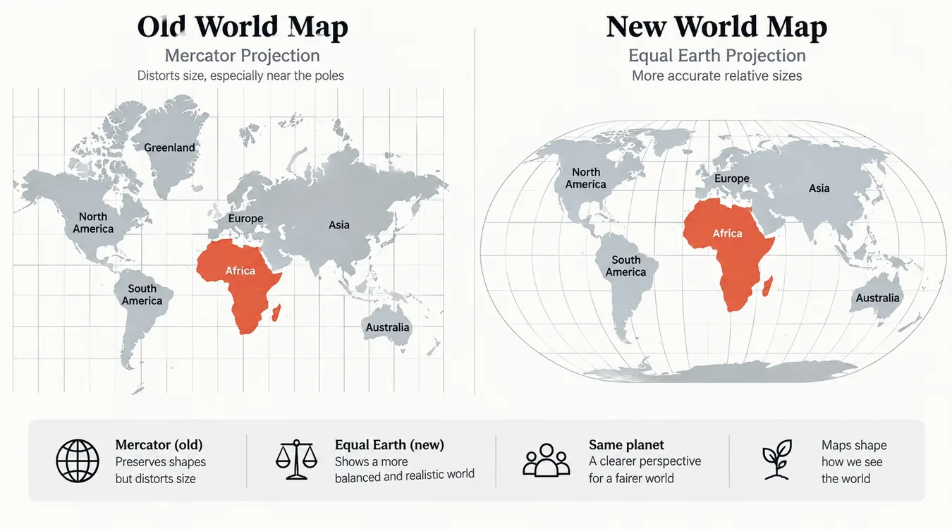
Created in the 16th century for navigation, Mercator preserves local angles and directions but dramatically enlarges landmasses closer to the poles. That makes Europe, Greenland, Canada and Russia appear disproportionately large while reducing the apparent size of Africa and other regions closer to the equator.
The Equal Earth projection takes a different approach.
Introduced in 2018 by cartographers Bojan Šavrič, Tom Patterson and Bernhard Jenny, Equal Earth is an equal-area pseudocylindrical projection. In practical terms, it preserves the relative area of landmasses far more faithfully than Mercator while maintaining a visually familiar world-map shape.
The UN resolution encourages governments, educational institutions and technology companies to use representations that show continents at more accurate relative sizes.
It does not redraw national frontiers.
It does not recognize one country’s sovereignty claim over another.
And it does not alter international law.
The current Japan-Russia dispute emerged because a political boundary layer placed on the Equal Earth projection used the same colour for the contested islands and Russia.
For Tokyo, that visual treatment implies an answer to a sovereignty question that remains unresolved.
Japan says the map creates a territorial misconception
The four islands at the centre of the dispute are Etorofu, Kunashiri, Shikotan and the Habomai islets.
Japan collectively calls them the Northern Territories.
They are administered by Russia but claimed by Japan.
Tokyo’s official position is that the four islands are an inherent part of Japanese territory and are under illegal Russian occupation. Moscow rejects that interpretation and regards the islands as Russian territory.
Japan’s concern is therefore not that Equal Earth changed the shape or location of the islands.
It is that the political map’s colour scheme visually groups them with Russia.
Kihara said the depiction contradicted the government’s position and warned that Tokyo needed to prevent misconceptions about Japanese territory and geographical names from spreading.
Japan asked the map operator to correct the depiction through diplomatic channels.
That response highlights a problem faced by every global political map: visual simplicity can imply legal certainty where none exists.
A solid colour suggests sovereignty.
A boundary line suggests recognition.
A label can imply official terminology.
For disputed territory, those design choices are political whether or not the cartographer intended them to be.
The territorial dispute dates to the end of World War II
The Japan-Russia dispute over the islands has prevented the two countries from concluding a formal postwar peace treaty.
Japan says the Northern Territories were not part of the Kuril Islands it renounced after World War II and points to historical agreements with Russia to support its claim.
The Soviet Union entered the war against Japan in August 1945 and Soviet forces occupied the four islands between late August and early September.
The islands were subsequently incorporated into the Soviet system, and the Japanese residents were removed in the years that followed.
Russia, as the Soviet Union’s successor state, has continued to administer the territory.
Japan has maintained that sovereignty over all four islands must be resolved as part of a peace treaty.
The disagreement has survived decades of negotiations and periodic attempts to improve bilateral relations.
The war in Ukraine has made those negotiations even more difficult.
Putin’s August visit made the map issue more sensitive
The cartographic dispute comes less than a month after Russian President Vladimir Putin visited Etorofu Island on August 13.
Japan immediately protested.
Foreign Minister Toshimitsu Motegi summoned the Russian ambassador and said the visit was incompatible with Japan’s position on the Northern Territories. The Japanese government described the visit as damaging to already difficult Japan-Russia relations.
That episode increased the political sensitivity surrounding any international depiction of the islands.
From Tokyo’s perspective, showing the territory in the same colour as Russia shortly after a highly symbolic presidential visit risks reinforcing what Japan considers an incorrect territorial assumption.
For Moscow, however, Russian administration of the islands is an established fact.
The disagreement illustrates a basic challenge for global mapping systems: a map can accurately show who administers territory without necessarily resolving who legally owns it, but users do not always interpret those distinctions.
Japan supported the UN resolution despite the dispute
Japan’s complaint does not mean it opposes the purpose of the “Correct the Map” initiative.
Tokyo was among the 164 UN members that voted in favour of the resolution.
That is significant because it separates Japan’s support for more accurate area representation from its objection to the treatment of disputed borders.
The African-led campaign behind the resolution focuses on the visual distortion created by Mercator maps.
Africa covers roughly 30 million square kilometres and is about 14 times the size of Greenland, yet Mercator maps can make the two appear far closer in size.
An equal-area projection corrects that visual imbalance.
The policy objective is therefore about relative geographic scale.
Japan’s challenge is about political geography.
Those are different problems embedded in the same map.
Ukraine raised a similar concern
Japan is not the only country to view the political boundary layer as consequential.
Ukraine abstained in the UN vote after objecting to how occupied Crimea was depicted.
Kyiv has consistently argued that Crimea remains sovereign Ukrainian territory despite Russian occupation.
The appearance of multiple territorial objections demonstrates why adopting a world-map projection is technically easier than agreeing on the political information drawn over it.
Projection mathematics can be calculated.
Territorial sovereignty cannot.
A global map must therefore decide how to represent disputed areas without appearing to endorse one claimant.
Common approaches include dashed boundaries, cross-hatching, separate colour treatment, explanatory labels or legends identifying disputed administration.
The UN resolution itself does not prescribe a universal solution to every territorial dispute.
Why Equal Earth is technically different from Mercator
Every flat map distorts the globe in some way.
The Earth is three-dimensional, while a wall map, textbook page or screen is two-dimensional.
A projection has to sacrifice some combination of area, shape, direction or distance.
Mercator was engineered for navigation.
Because it preserves angles locally, sailors could plot a constant compass bearing as a straight line. That was extraordinarily useful for maritime navigation.
Its weakness is scale.
The farther a location is from the equator, the more its area is exaggerated.
Equal Earth prioritizes area instead.
If one region is twice the physical area of another, an equal-area map aims to preserve that ratio visually.
The trade-off is that shapes and angles cannot remain perfectly accurate everywhere.
Equal Earth therefore is not a “perfect” world map.
No flat projection can be.
Its value is that it is designed for applications where comparative land area matters more than navigational geometry.
That makes it particularly useful for education, thematic maps, global statistics, environmental analysis and public communication.
The controversy exposes a second layer of map accuracy
The UN debate has largely focused on geometric accuracy.
Japan’s protest shows that political accuracy is a separate problem.
A technically correct projection can still contain a politically disputed boundary.
A country can be shown at the correct relative size while its borders are contested.
And a dataset can correctly reflect de facto administration while conflicting with a government’s de jure sovereignty claim.
Modern mapping platforms handle these problems at enormous scale.
The same base-map data can appear in navigation software, school materials, dashboards, media graphics, government documents and AI-generated outputs.
That means a cartographic decision can propagate rapidly.
A colour assigned to a tiny island on one master dataset may eventually appear on millions of screens.
For governments involved in territorial disputes, those design decisions are therefore treated as diplomatic issues rather than cosmetic details.
What happens next
Japan has requested a correction, but the exact form of any change has not been publicly settled.
The operator could potentially distinguish the islands visually, add disputed-boundary notation or alter labels and legends.
Any such solution would have to balance clarity with the fact that Russia exercises current administrative control while Japan maintains its sovereignty claim.
The United Nations also faces a broader question as Equal Earth gains wider institutional use.
If the projection becomes a standard educational or digital reference, the boundary data layered over it will receive more scrutiny.
The map reform was designed to correct distortions in how the world’s landmasses are perceived.
It has now exposed a different category of distortion: the risk that visual design can make an unresolved geopolitical dispute look settled.
A map can be mathematically neutral and politically consequential
Japan’s challenge to the new map is not an argument against the mathematics of Equal Earth.
It is an argument about what a political map communicates.
The UN initiative seeks to give continents, particularly Africa, a more accurate visual scale after centuries of Mercator dominance. That objective remains intact.
But once borders, colours and state labels are added, a world map stops being only a geometric projection.
It becomes a representation of the international system.
For Japan and Russia, four small islands in the northwest Pacific carry the weight of an unresolved war settlement, decades of failed diplomacy and competing sovereignty claims.
That is why a change in colour on a global map can trigger a formal diplomatic protest.
The Equal Earth debate began with a simple proposition: continents should be shown closer to their true relative size.
Japan’s objection is a reminder that showing the world accurately also requires deciding how to represent places where the world itself has not agreed on the answer.
Reader questions
Frequently asked questions
Why is Japan challenging the new UN-backed world map?
Japan says the political map visually groups the four disputed Northern Territories with Russia, contradicting Tokyo’s sovereignty claim.
Did Japan oppose the UN Equal Earth resolution?
No. Japan was among the 164 countries that voted in favour. Its complaint concerns the depiction of disputed territory rather than the equal-area projection itself.
What is the Equal Earth projection?
Equal Earth is an equal-area pseudocylindrical world-map projection introduced in 2018. It preserves the relative size of regions more accurately than the Mercator projection.
Does the UN map decide whether the disputed islands belong to Japan or Russia?
No. A map projection does not determine sovereignty, and the General Assembly resolution does not settle the Japan-Russia territorial dispute.
Which islands does Japan call the Northern Territories?
Japan uses the term for Etorofu, Kunashiri, Shikotan and the Habomai islets.
Who currently controls the islands?
Russia currently administers the islands. Japan claims sovereignty over the four territories and maintains that Russian occupation has no legal basis.
Why does the Mercator projection make Africa look smaller?
Mercator increasingly enlarges areas farther from the equator. Equal Earth preserves area instead, so continents appear closer to their true relative sizes.
Nexuswild welcomes factual corrections. Email [email protected] with evidence and the article URL.