
Scientists Identify ‘Permafrost Detachment Slides’ After Massive Landslides in Canada’s Northwest Territories
Researchers studying two major landslides in Canada’s Northwest Territories have identified a distinct form of permafrost failure in which large sections of frozen ground detach near their base and move rapidly downslope. The findings, published in Geophysical Research Letters, suggest that wildfire damage and long-term warming can weaken frozen terrain deep underground, potentially creating a hazard that emerges years after the initial disturbance.
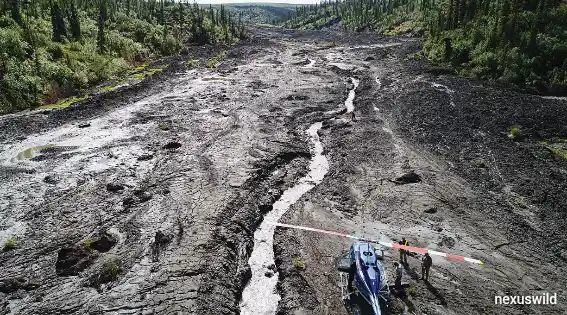
The study examines the Johnson River and Redstone River landslides, which occurred in 2017 and 2018. Together, the events mobilized millions of cubic metres of ground, reshaped river valleys and created debris deposits capable of obstructing drainage. The researchers call these failures permafrost detachment slides, distinguishing them from more familiar landslides in which thawed surface material gradually slumps downhill.
Two landslides reveal a different failure mechanism
The Johnson River landslide occurred in August 2017 in the central Mackenzie Valley. Researchers estimated that the initial failure mobilized approximately 17.2 million cubic metres of material, with later enlargement and secondary processes bringing the estimated total disturbed volume to around 18.6 million cubic metres.
The Redstone River landslide followed in August 2018, moving approximately 4.5 million cubic metres of ground into the river basin. Although the sites differ in their terrain and geological characteristics, the researchers found important similarities in the way the frozen ground failed.
Both events involved cohesive blocks of permafrost moving along a deep sliding surface. At the Redstone River site, researchers observed a basal failure plane about 20 metres below the undisturbed ground surface. At the Johnson River site, the original surface was obscured by later thaw-related changes, but geological evidence indicated a failure depth of roughly 18 metres.
These dimensions help explain why the events differ from more typical surface-driven thaw slumps. Rather than beginning with a shallow layer of soil that progressively melts and collapses, the failures involved much deeper portions of the frozen ground.
How thaw from below can destabilize frozen ground
Permafrost is ground that remains at or below 0°C for at least two consecutive years. It can contain varying amounts of soil, rock, organic material and ground ice. In parts of the Arctic and subarctic, frozen ground helps maintain the structure of slopes and landscapes.
When surface vegetation and its insulating organic layer are damaged by wildfire, more heat can enter the ground. The effects are not necessarily confined to the first few seasons after a fire. Heat can propagate slowly through the subsurface, changing the temperature and ice content of deeper layers over many years.
In the Northwest Territories cases, the researchers used field observations, geological analysis, remote sensing and thermal modelling to investigate this process. Their results support a mechanism in which thaw progresses toward the base of a relatively thin permafrost layer. As ground ice melts and the material’s properties change, the basal zone can become less stable.
The study’s thermal modelling indicates that fire-related changes can affect the base of permafrost on decadal timescales. A wildfire in 1995 provided important context for the researchers’ comparison of burned and unburned ground. The findings suggest that the consequences of such disturbances may emerge long after the visible burn scar has begun to recover.
The exact timing and contribution of each factor remain dependent on local conditions. The research does not establish that every wildfire will produce a landslide two decades later, nor that a single fire alone explains both events.
Why the landslides can move so much material
The researchers propose that gradual movement and the development of tension cracks can allow water to enter the ground. This infiltration may accelerate thaw at depth and contribute to failure along the base of the frozen layer.
Once a large section detaches, it can move as a relatively cohesive mass rather than immediately turning into a flowing mixture of mud and water. The resulting deposits can include large frozen blocks and thick accumulations of debris.
The Johnson River and Redstone River events altered local drainage and produced debris-dammed lakes. Such deposits can continue to change after the initial landslide as exposed ice melts, slopes retreat and water moves sediment downstream.
The longer-term effects therefore extend beyond the day of failure. Continued thawing can enlarge exposed scarps, while erosion and sediment transport can alter nearby rivers and aquatic environments.
Hundreds of similar landslides identified
The study reports hundreds of similar landslides in parts of the Mackenzie Valley where permafrost is relatively thin—less than 40 metres—and warm, with ground temperatures above approximately −1°C. These conditions do not mean that every mapped location will fail; they help identify terrain where the mechanism may be relevant.
Satellite-image analysis cited by the researchers also indicates a marked intensification of deep-seated permafrost landslides in the central Mackenzie Valley between 2004 and 2020. The findings point to a broader regional change rather than two isolated events alone.
However, a mapped landslide or potentially susceptible slope is not automatically an imminent threat to a road, pipeline, community or other asset. Determining local risk requires detailed assessment of slope conditions, ground temperature, ice content, surface movement, drainage and the location of infrastructure.
Implications for northern communities and infrastructure
The findings may be relevant to planning for roads, pipelines, water infrastructure and other assets built across permafrost terrain. A failure that begins deep below the surface may not be adequately understood through observations of surface thaw alone.
Monitoring could combine satellite imagery, repeat elevation surveys, ground-temperature measurements, field inspections and geophysical investigations. Changes such as growing tension cracks, progressive downslope movement and new water ponding may provide clues that a slope is becoming unstable, although these indicators do not guarantee that a failure will occur.
For engineers and public agencies, the research provides a reason to consider delayed effects of wildfire and warming in long-term assessments of northern landscapes. It does not, by itself, demonstrate that specific highways or pipelines are at immediate risk, and it does not document damage to the Dempster Highway or other named infrastructure from the two studied slides.
What the research means for climate-risk assessment
The study adds a distinct failure mechanism to the scientific understanding of thaw-driven landslides. Its central message is that permafrost instability can develop below the surface and emerge after a long delay, making the timing and location of some failures difficult to anticipate.
The researchers’ findings also highlight the combined influence of climate warming, wildfire disturbance, ground ice and local geology. These factors interact differently across the North, so the results should inform further investigation rather than be applied as a universal prediction for every permafrost region.
The next challenge is to determine how widely this mechanism occurs, which measurable changes provide reliable early warnings and how risk maps can distinguish susceptible terrain from slopes likely to fail. Better answers could help northern communities and infrastructure planners make more informed decisions as frozen landscapes continue to change.
Nexuswild welcomes factual corrections. Email contact@nexuswild.com with evidence and the article URL.