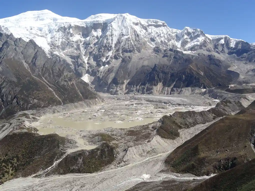

The Indian Himalayan region is one of the most ecologically fragile and strategically vital landscapes in South Asia. Spanning over thousands of kilometers, it is the source of major river systems that sustain hundreds of millions of people. However, the region is currently undergoing a profound environmental transformation. As global temperatures rise, the rapid melting of high-altitude glaciers is giving birth to thousands of new, rapidly expanding water bodies known as glacial lakes. While these lakes represent a critical freshwater reserve, they also pose an existential threat to the densely populated valleys below.
The phenomenon known as a Glacial Lake Outburst Flood (GLOF) has rapidly emerged as one of the most severe natural disaster risks facing India's mountain states. When the fragile natural dams containing these immense bodies of water fail, they release catastrophic torrents of water, ice, and debris that can obliterate everything in their path. The vulnerability of Himalayan hill towns, infrastructure projects, and local economies to these sudden deluges is no longer a theoretical concern - it is an active crisis.
Following recent devastating events, Indian scientific agencies and disaster management authorities have drastically accelerated their monitoring and mitigation efforts. Recent assessments reveal that out of approximately 7,500 glacial lakes in the Indian Himalayas, 189 have been flagged as high-risk, with 56 categorized as very high risk. This escalating threat demands a comprehensive understanding of what GLOFs are, why they are becoming more frequent, and how technology and policy can mitigate their impact on vulnerable mountain communities.
What Is a GLOF?
A Glacial Lake Outburst Flood (GLOF) occurs when the containment boundary - or natural dam - of a glacial lake suddenly breaches, releasing an enormous volume of accumulated meltwater downstream. To understand the mechanics of a GLOF, it is essential to look at how these lakes form.
As glaciers slowly retreat due to rising temperatures, they leave behind depressions in the landscape. Simultaneously, the melting ice produces vast quantities of water that fill these depressions. The water is typically held back by a "moraine" - a naturally occurring accumulation of loose rocks, boulders, gravel, and ice debris that the glacier bulldozed forward during its historical advance.
Unlike engineered concrete dams, moraine dams are inherently unstable. They lack structural cohesion and are highly susceptible to sudden failure. A GLOF is triggered when this fragile barrier gives way. The breach can be initiated by several natural or human-induced factors. A massive ice avalanche or rockfall crashing into the lake can displace the water, creating a tsunami-like wave that overtops and erodes the moraine. Seismic activity, such as earthquakes, can easily fracture the loose debris. Additionally, extreme weather events, like sudden cloudbursts or prolonged heavy rainfall, can rapidly increase the lake's water volume until the hydrostatic pressure simply blows out the natural dam.
Once a breach occurs, the resulting flood is radically different from a standard riverine flood. A GLOF carries a deadly mixture of liquid water, massive boulders, glacial till, and uprooted trees. This highly abrasive slurry travels at extraordinary speeds down steep mountain gradients, possessing enough kinetic energy to shear the foundations of concrete bridges and scour entire hillsides down to the bedrock.
Why Himalayan Glacial Lakes Are Expanding
The primary driver behind the increasing frequency and severity of GLOF threats is the accelerated rate of glacier retreat. The Himalayas are often referred to as the "Third Pole" because they contain the largest concentration of frozen freshwater outside the polar regions. However, this high-altitude cryosphere is highly sensitive to climatic shifts.
Recent scientific assessments indicate that Himalayan glaciers are losing mass 65 percent faster than they were just a decade ago. This alarming acceleration is primarily attributed to elevation-dependent warming, a phenomenon where high mountain environments experience temperature increases at a substantially faster rate than the global average. As the ice melts at an unprecedented pace, existing glacial lakes swell, and new supraglacial lakes (pools of water forming on top of the glacier surface) emerge and coalesce into larger, deeper bodies of water.
For instance, satellite observations have tracked the dramatic expansion of several high-risk lakes. Analysis of lakes in regions such as the Mago Chu Basin in Arunachal Pradesh reveals consistent expansion over the last decade. As these lakes grow larger, the volume of water pressing against the fragile moraine dams increases, proportionally raising the potential destructive energy of an outburst event. The expanding surface area also makes the lakes wider targets for avalanches and rockfalls, increasing the statistical probability of a trigger event.
Risks to Hill Towns and Infrastructure
The geographic reality of the Himalayas means that human settlements and critical infrastructure are frequently situated in narrow river valleys directly downstream from expanding glacial lakes. Over the past few decades, these valleys have witnessed rapid urbanization, population growth, and extensive infrastructure development, dramatically increasing the exposure to GLOF hazards.
Himalayan hill towns are particularly vulnerable. Settlements built on historic floodplains or low-lying river terraces have little to no buffer against a sudden outburst flood. Local economies, which rely heavily on agriculture, pastoralism, and tourism, face total disruption. The destruction of arable land, loss of livestock, and wiping out of connecting roads can isolate communities for months, crippling their primary sources of income.
Furthermore, the Himalayas are the epicenter of India's hydroelectric power ambitions. Numerous run-of-the-river hydropower projects have been constructed along glacier-fed rivers to harness their immense energy potential. However, these multi-million-dollar engineered structures are rarely designed to withstand the sheer impact force and sediment load of a massive GLOF. If a GLOF destroys a dam, it not only results in massive financial losses and grid disruptions but also creates a cascading disaster, as the sudden release of the dam's reservoir compounds the flood volume traveling further downstream to populated plains.
Recent GLOF Events and Their Impact
The devastating potential of these outburst floods is well-documented in recent Indian history. The catastrophic floods in the Kedarnath region of Uttarakhand in 2013 were exacerbated by the breaching of the Chorabari glacial lake, resulting in unparalleled loss of life and infrastructure. However, the most definitive modern example of a GLOF's destructive power occurred in the northeastern state of Sikkim in October 2023.
High in the Sikkim Himalayas, the South Lhonak Lake had been identified by scientists for years as a high-risk glacial lake. Between 1977 and 2008, the lake had swelled from 17 hectares to nearly 100 hectares as the feeding glacier retreated. On the night of October 3, 2023, following intense cloudbursts that dumped more than double the normal rainfall over the region, the lake's moraine dam suffered a catastrophic breach. Satellite imagery from the Indian Space Research Organisation (ISRO) later confirmed that the lake's surface area shrunk by more than 100 hectares overnight, indicating the massive volume of water that was abruptly released.
The floodwaters surged down the Teesta River basin. The deluge reached the 1,200 MW Teesta III Dam at Chungthang just after midnight. The volume and force of the GLOF obliterated the dam in minutes before the operators could effectively manage the spillway gates. The downstream water levels rose by an estimated 20 feet, washing away 15 critical bridges and destroying stretches of National Highway 10, effectively cutting off the state capital, Gangtok, and stranding thousands of tourists. The disaster claimed at least 92 lives, including several Indian Army personnel, and forced the evacuation of thousands of residents into relief camps. The event served as a tragic, real-world validation of the extreme risks posed by unchecked glacial lakes.
Monitoring and Early-Warning Systems
In the aftermath of the Sikkim disaster, Indian authorities have vastly expanded their scientific monitoring networks. Tracking glacial lakes across thousands of square kilometers of rugged, high-altitude terrain requires highly advanced remote sensing technology.
The Central Water Commission (CWC), alongside the National Remote Sensing Centre under ISRO, continuously monitors the Himalayan river basins. Utilizing high-resolution satellite imagery, scientists track the formation, growth patterns, and structural integrity of over 900 water bodies across the region. By analyzing time-series satellite data, glaciologists can measure exactly how fast a lake is expanding and assess the geological stability of the surrounding slopes to calculate the likelihood of an avalanche-triggered breach.
However, satellite data alone is insufficient. While remote sensing acts as a crucial preliminary screening tool, precise risk assessment requires physical, on-the-ground investigations. The National Disaster Management Authority (NDMA) has finalized a priority list of 189 high-risk lakes across the Indian Himalayas that require immediate field verification and mitigation. To achieve this, multidisciplinary expedition teams conduct complex bathymetric surveys (mapping the depth and floor of the lake) and geophysical assessments of the moraine dams.
Establishing functional Early Warning Systems (EWS) is the ultimate goal of this monitoring network. An effective EWS involves installing Automated Weather and Water Level Monitoring Stations (AWWS) directly at the high-risk lakes. If the sensors detect an abnormal, rapid spike in water levels, an automated alert is instantly transmitted via satellite link to downstream control centers. This crucial lead time - even if it is just a few hours - allows disaster response teams to open downstream dam gates, evacuate low-lying settlements, and halt traffic on vulnerable bridges, vastly reducing the potential loss of life.
India’s Disaster Preparedness and Mitigation Efforts
Recognizing that monitoring must be paired with proactive intervention, the Government of India recently approved the National Glacial Lake Outburst Floods Risk Mitigation Programme (NGRMP). Backed by a financial outlay of ₹150 crore, the project is being implemented across four highly susceptible mountain states: Arunachal Pradesh, Himachal Pradesh, Sikkim, and Uttarakhand.
The NGRMP is a comprehensive, multi-component strategy aimed at physically reducing the hazard at its source. One of the most critical aspects of the program involves complex "lake-lowering measures". If a field expedition determines that a high-risk lake is dangerously full, civil engineering interventions are deployed to siphon off the excess water. In 2018, preliminary efforts at South Lhonak Lake involved utilizing yaks to carry specialized high-altitude pipelines up the mountain to physically pump water out of the basin. The new national program scales up these site-specific interventions, combining advanced technical engineering with indigenous knowledge to reinforce fragile moraine dams and buffer against overflow.
Furthermore, the mitigation program places a strong emphasis on community capacity building. In the event of a midnight breach, local awareness and immediate, unpanicked reaction are the difference between life and death. The government is investing in last-mile connectivity, ensuring that early warning alerts reach remote agro-pastoral communities seamlessly, and conducting regular evacuation drills to strengthen institutional preparedness at the district and village levels.
Scientific and Expert Views
Glaciologists and climate scientists view the GLOF phenomenon as one of the most complex and rapidly evolving fields of disaster science. Experts note that treating GLOFs simply as flood events severely underestimates their unique physics and sheer destructive capability.
According to Dr. Sandeep Tambe, a leading expert and official involved in Sikkim's mitigation efforts, GLOF management requires continuous scientific advancement. He likens remote satellite sensing to a preliminary health screening, while stressing that physical field investigations are the necessary "CT scans and X-rays" required to prescribe a specific engineering treatment for an unstable lake.
Despite the recent push for monitoring, broader regional reports highlight a severe data deficit. Experts estimate that of the roughly 40,000 glaciers scattered across the wider Hindu Kush-Himalayan region, only about 0.1 percent are subject to regular, consistent scientific observation. Researchers warn that without scaling up ground-based instruments and establishing a more robust network of automated sensors, predicting future disasters in a rapidly warming climate remains highly difficult.
Furthermore, experts emphasize that while climate change acts as the overarching threat multiplier by accelerating glacier melt and lake expansion, individual GLOF triggers - such as unpredictable earthquakes or localized rockfalls - cannot always be attributed directly to long-term climate trends. Therefore, mitigation must focus heavily on physical preparedness and infrastructure resilience rather than solely relying on atmospheric climate models.
Challenges and the Road Ahead
Implementing a robust GLOF mitigation strategy across the Himalayas is fraught with immense logistical and geopolitical challenges. The primary obstacle is the physical terrain. High-risk lakes are located in harsh, hypoxic, and entirely inhospitable environments at elevations frequently exceeding 15,000 feet. The weather window for mounting scientific expeditions or transporting heavy engineering equipment is exceptionally narrow, generally limited to the few months between July and September.
Additionally, the behavior of supraglacial lakes adds a layer of extreme unpredictability. These smaller pools of water forming on the glacier's surface can merge, drain, and reform rapidly across a single melting season. Tracking these dynamic, short-lived water bodies via static satellite inventories is highly challenging, requiring continuous, high-frequency radar imaging.
The transboundary nature of Himalayan river basins also necessitates international cooperation. A glacial lake situated across the border in Tibet can easily breach and devastate downstream valleys in India, just as an Indian GLOF can impact communities further downstream in Bangladesh or Bhutan. Establishing real-time data-sharing protocols and unified early warning systems among the nations of the Hindu Kush-Himalayan region is critical for comprehensive disaster risk reduction.
Looking ahead, infrastructure planning in mountain states must undergo a paradigm shift. Development projects, particularly hydropower dams and highways, must incorporate mandatory GLOF hazard mapping and climate-risk screening into their initial design phases. Building expensive infrastructure directly in the historical runout zones of known glacial lakes is an unacceptable risk in the modern era.
Conclusion
The expansion of glacial lakes in the Indian Himalayas serves as a profound and highly visible indicator of a changing planetary climate. As these high-altitude water bodies continue to swell against fragile natural dams, the threat of Glacial Lake Outburst Floods will only intensify. For the vulnerable hill towns, vital hydropower infrastructure, and millions of residents nestled in the valleys below, the margin of safety is rapidly shrinking.
However, the catastrophic events of the past decade have spurred a necessary evolution in disaster management. Through the targeted identification of high-risk lakes, the deployment of advanced ISRO satellite monitoring, and the well-funded National GLOF Risk Mitigation Programme, India is actively transitioning from a reactive approach to a proactive, science-driven defense strategy. While the physical and logistical challenges of taming the Himalayas remain monumental, strengthening early warning systems, executing physical lake-lowering measures, and building community resilience offer the most viable path toward securing the future of India's mountain communities against the rising tide of glacial floods.
Further reading and useful links
Reader questions
Frequently asked questions
What causes a Glacial Lake Outburst Flood (GLOF)?
A GLOF occurs when the natural moraine or ice dam holding back a glacial lake breaches. This can be triggered by avalanches, earthquakes, heavy rainfall, or the sudden collapse of unstable debris.
Why are glacial lakes expanding in the Himalayas?
Rising global temperatures and elevation-dependent warming are causing Himalayan glaciers to melt at a significantly accelerated rate. As the ice retreats, it leaves behind increasing volumes of meltwater that expand existing lakes and form new ones.
Which areas in India are most at risk from GLOFs?
Himalayan states, including Sikkim, Arunachal Pradesh, Himachal Pradesh, and Uttarakhand, are highly susceptible. The NDMA has flagged 189 high-risk lakes across the Indian Himalayan region.
What happened during the South Lhonak Lake GLOF in 2023?
In October 2023, the South Lhonak Lake in Sikkim breached following intense rainfall. The resulting flood destroyed the 1,200 MW Teesta III dam, washed away 15 bridges, and caused at least 92 confirmed fatalities downstream.
How is India mitigating the GLOF threat?
India recently launched the ₹150-crore National GLOF Risk Mitigation Programme to conduct hazard assessments, install early warning systems, and perform physical lake-lowering operations at high-risk sites.
Nexuswild welcomes factual corrections. Email [email protected] with evidence and the article URL.